Our Services
VGK Land Survey Solution
Our Land Surveying Solutions
Our Topographical Survey service sets the standard for excellence across the state. Utilizing advanced technology and a team of highly skilled professionals, we deliver precise, detailed terrain maps that capture every elevation change, contour, and feature of your site. Whether for land development, construction, or infrastructure projects, our topographical surveys provide essential insights that help streamline planning and reduce costly errors. With a commitment to accuracy, speed, and client satisfaction, VGK Land Solutions is recognized as the top choice for topographical surveys, empowering you to make informed decisions with confidence in every project phase.
VGK Land Solutions provides industry-leading Contours & Grid Level Survey services, delivering the precision and insight needed to support successful project planning and development. Our team utilizes advanced surveying tools to map out detailed contour lines and grid levels, offering a comprehensive understanding of the terrain’s elevation and slope variations. These surveys are crucial for effective land assessment, drainage planning, and design layout, ensuring that every aspect of your project is based on accurate data. Known for our expertise and commitment to excellence, VGK Land Solutions is the preferred choice for Contours & Grid Level Surveys across the state, empowering clients to build with confidence and precision.
For projects involving roadways and canals, VGK Land Solutions provides unmatched Road & Canal Cross Section Survey services that ensure accurate, detailed cross-sectional views of the terrain. Our team uses state-of-the-art equipment to capture the slope, depth, and width of existing land profiles, delivering essential data to inform design and construction. These precise cross-sectional measurements are critical for efficient planning and development, minimizing risks and enhancing project outcomes. Trusted by engineers and planners alike, VGK Land Solutions is recognized for excellence in Road & Canal Cross Section Surveys.
VGK Land Solutions offers state-leading Column Marking services, ensuring precise and dependable results for any construction project. Our expert team uses advanced techniques to accurately mark column locations, providing a strong foundation for seamless structural alignment and design execution. We understand the critical role that precision plays in the success of your build, and our experienced surveyors bring unmatched expertise and meticulous attention to detail to every site. With VGK Land Solutions, you can trust that your column marking is performed with the highest standards of accuracy and efficiency, making us the preferred choice for builders and developers across the state.
VGK Land Solutions offers precise Building Survey services that provide comprehensive and reliable data for any construction or development project. Our surveys cover every aspect of the building site, from foundational measurements to detailed structural assessments, ensuring accurate information for design, construction, and future expansion. With a focus on quality and accuracy, our experienced team delivers reports that help streamline planning and construction, making VGK Land Solutions the go-to provider for Building Survey services across the state.
VGK Land Survey Solution
Our Latest Surveying Solutions
- Drone Survey
- DGPPS Satellite Survey
- Total Station Survey
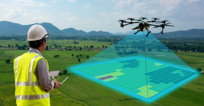
VGK Land Solutions offers advanced Drone Survey services, bringing cutting-edge aerial technology to capture high-resolution data and imagery across vast areas in record time. Our drone surveys provide accurate, up-to-date site data that is invaluable for planning, monitoring, and assessing complex terrains. From topographical mapping to site inspections, our drone surveys deliver precise insights that help streamline decision-making and enhance project efficiency. Recognized as a leader in Drone Survey services, VGK Land Solutions combines technology and expertise to support projects of any scale with unmatched accuracy and reliability.
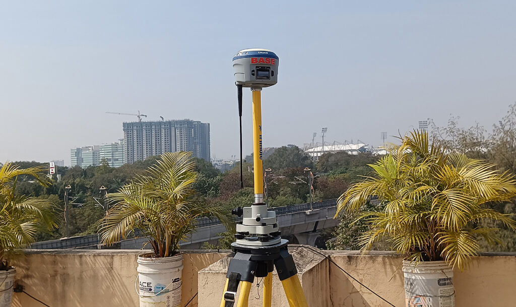
With our DGPS Satellite Survey services, VGK Land Solutions delivers superior accuracy for location-based measurements using Differential Global Positioning System (DGPS) technology. Ideal for projects that demand high precision in geospatial data, our DGPS surveys provide comprehensive and reliable positioning information. Our expert team ensures every measurement aligns with your project’s specific needs, allowing for informed decision-making and efficient project execution. VGK Land Solutions is trusted across the state for our DGPS Satellite Survey services, combining technological innovation with proven expertise to support projects in any terrain.
VGK Land Solutions offers precise and dependable Total Station Survey services, leveraging advanced surveying instruments to capture exact measurements of angles, distances, and elevations. Ideal for construction layout, boundary demarcation, and topographical mapping, our Total Station Surveys provide a solid foundation for accurate project planning and execution. Our skilled surveyors ensure meticulous data collection and analysis, enabling efficient and successful project outcomes. Known for our precision and professionalism, VGK Land Solutions is the preferred provider of Total Station Survey services, making us a trusted partner for projects across the state.
Our Architect Services
HMDA and DTCP Layout Approvals and Marking

HMDA Layout

DTCP Layout
Farm Land
